
John and I went up to Taboose Pass for an early season Sierra backpack and attempt to ascent 2 mountains: Striped Mtn. (13,185 ft / 4019 m), Cardinal Mtn. (13,402 ft / 4085 m).
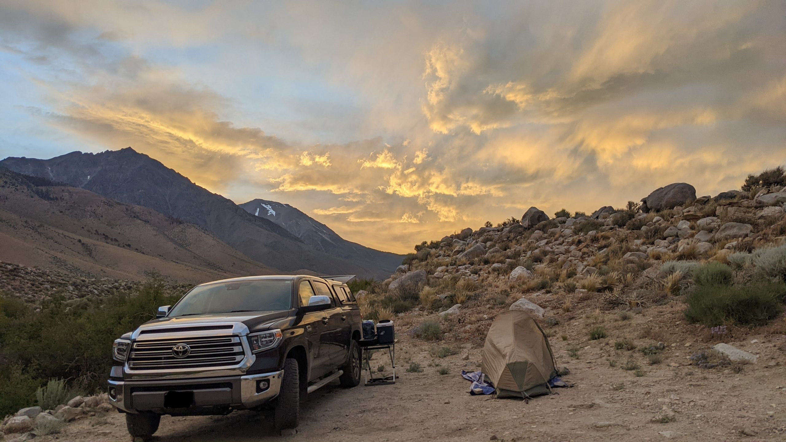
With daytime temperatures in the area of the trailhead already in the 90’s we wanted to get an early start the next morning. So we met Thursday afternoon at John’s and carpooled to the Taboose Pass Trailhead where we set up camp in the early evening. There was some wind, but that kept the bugs away.
Day 1:
After breaking up camp we started hiking around 6:30. We made good progress until about 9,500 ft when the effects of the thinner air became more and more obvious. Just below 10,000 ft we encountered the first snowfield. Fortunately, it had softened and we were able to cross snowfields without too much slipping or post-holing. The pass plateau itself was covered with large snowfields, but they also were soft in the middle of the day. It took us almost 8h to cover the 7.1 miles (11.4 km) and 6000 ft (1828 m) elevation gain to 11,350 ft (3460m). Since it was windy up there we spent some time walking around looking for a somewhat sheltered campsite. The spot we picked was a bit sloped and John ended up moving his tent after night one because he was just slipping down in his tent too much. Exhausted from the effort we crawled into our tents early right after dinner (~18:00).
Day 2:
After a windy and cold night (more for John than me since I had my winter sleeping bag) we got up to cloudy skies. We prepared our breakfast and headed towards Striped Mtn. Once we were able to see the slopes we would have to scale it became obvious that our chances of making this peak were slim. Too many very steep snowfields to cross. We started climbing anyway to see how far we could get [Note: hardly any of the Sierra peaks have trails]. At around 12,500 ft (3,800m) we called it a day, took a break, and turned back. We took our time to return to camp where we took a nap.
Later we went down the west side of Taboose Pass for a couple of hours of exploring. This gave us a chance to see Striped Mtn. from the “backside”. After another early dinner we were again in our tents just after 18:00.
Day 3:
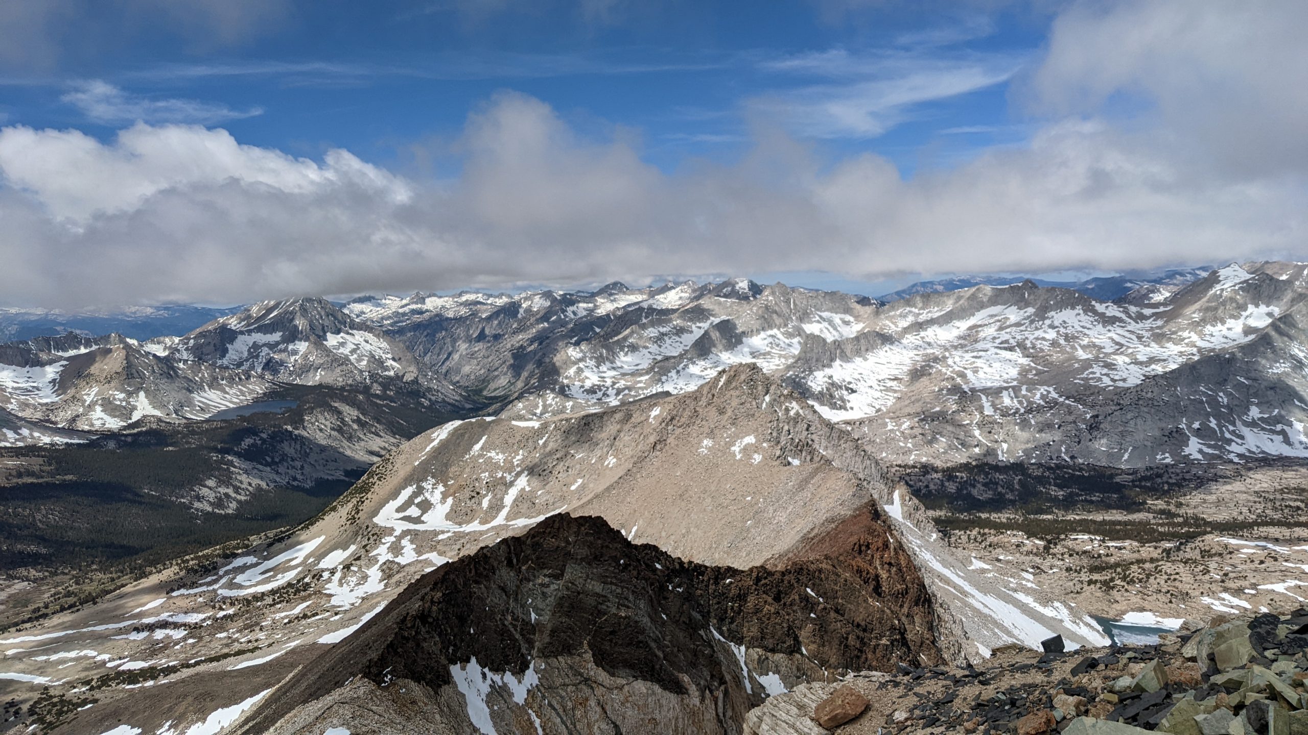
The wind was howling all night and when I got up to go to the bathroom at 2am I was met by dense fog when I opened my tent. If it stayed that way we would not attempt Cardinal the next day, but no need to worry just yet since conditions were changing fast. And they did indeed, when we got up we even had some sun hitting us. It was windy with temperatures around freezing, but the clouds were thining quickly. At least in the lower elevations. There were quick-moving clouds all day long with their base around 12,500 ft (3,800m). This meant that the peaks around us would end up with their tops covered at one time or another. We were lucky and stayed in the clear during our entire climb.
The climb was steep, but we found a decent route used by bighorn sheep. What they are doing up there is not clear to me, we hardly saw any kind of vegetation. Then at 12,900 ft (3,900 m) we even saw some mountain lion scat. What was that lion doing up there? Hunting bighorn or enjoying the view? The route was scree at the bottom transitioning into talus of various sizes as we went up. There was one section where we had to climb over some rocky ridges, fortunately none of the climbing was exposed. After a little over 2 hours and 2000 ft (600m) of climbing, we arrived at the top. The view was great, even though we did not get to see all the peaks due to the clouds. We stayed about 45 min having snacks and also checking if anything important had happened in the world as we had cell reception up there. We returned down the way we had come up for a total of 5h 27m away from camp.
Upon return to camp, we broke up camp and started back down. We wanted to get to some of the out-hike done and also camp out of the wind in a warmer place. There are some nice campsites at 9,500 ft (2,890m). It was warmer here, but the wind stayed with us.
Day 4:
We had 5 miles to hike with about 4,000ft (1220m) of elevation loss. The trail got progressively easier to negotiate, changing from talus, to scree, to sand for the last 1.5 miles. We arrive at the truck after 2h 15m and were on the road by 9 am. This turned out to be perfect timing since we passed through the LA basin with barely a slow down (not an easy feat).
(click on any image to enlarge/start slideshow)


Sounds like I missed an adventure