
After my Rainier trip, I had planned on going to the Sierras to climb with my friend Will. I had heard from Nick and Alicia that Will is insanely fast in the mountains and I was ready to test myself against his speed. Little did I know, but he has about 20 years of Sierra peakbagging experience and certainly knows his way around the mountains.
Our plan was to climb a few technical peaks, ones you really wouldn’t want to do without a rope and a partner. We settled on Charlotte Dome, Gardiner, Cotter and Clarence King.
Wednesday afternoon I left for Roads End in Kings Canyon Nation Park. I had never been there, and unlike driving to Lone Pine, the drive to Roads End is a traffic choked pain. I left work at 5PM and at 2AM arrived at the campsite where Will was already sleeping. In the morning we grabbed a breakfast burrito, packed our gear and got our permit. Will seemed to be in no hurry and we got a late start at noon.
Our plan for the day was to hike 8 miles into our first campsite near Charlotte Dome and just below 10,000ft. The trail begins by crossing some nice rivers and makes a steep ascent up some switchbacks. So far, we were hiking at 3mph and we easily completed 7 miles to the turn off for Charlotte Dome. From here though, I think the trail is more of a “suggestion” as it was difficult to follow and certainly not maintained. After a good bit of elevation gain, we realized this portion was kicking our butts. Furthermore, as I looked southwest I saw ominous looking clouds spilling over the nearest ridge. We both hustled a little more and found ourselves below Charlotte Dome and on some slabs. I had banged my knee pretty bad and was bleeding all over my leg. Great start. As we were making our way across some sketchy ledges I looked north and saw that it was snowing in the higher elevations, our target for the next day. Soon after, we found ourselves on some exposed, smooth slabs and it started to snow on us. Not exactly what you need when falling isn’t an option. I got sketched out and decided to turn around. Will forged ahead and did some climbing I didn’t want to do. I managed to go to the bottom of the slabs but then realized I had to climb a crack (maybe 5.2) to get over to the route. I climbed it, but was not happy doing it in hiking boots and with a 45 pound backpack. At the top, I found I climbed into a cliff and this route was not the way. Time to down climb and try again. After extensive bushwacking I made my way around and met up with Will. The rest of the climb into camp was uneventful. Unfortunately for us, daylight was running out and we would not be able to bag Charlotte that day. We made camp in a nice flat spot, got water, dinner and crashed for the the night.
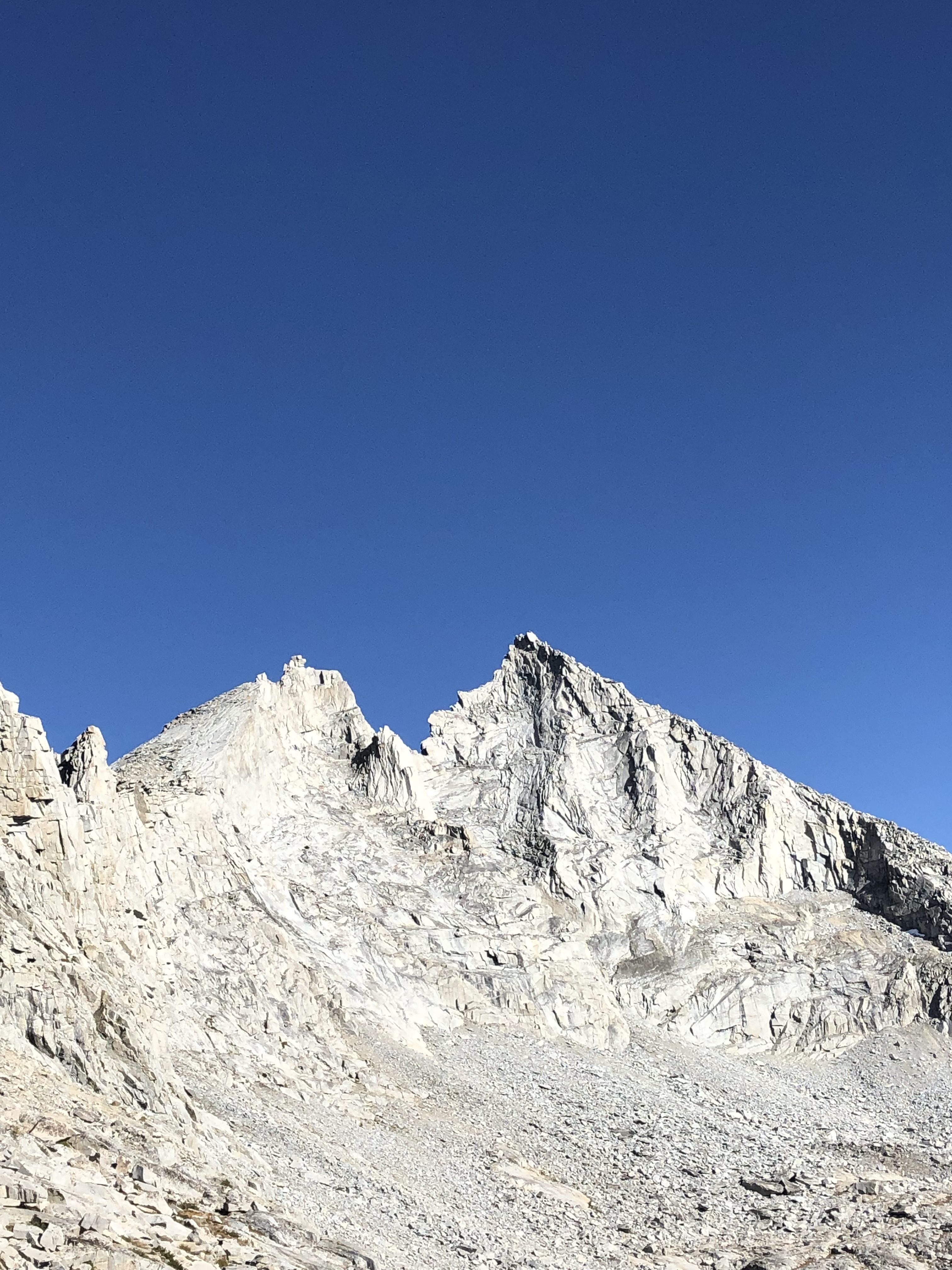
Thursday morning Will wanted to wake up “when the sun hits my tent” so we woke up at 8AM and started hiking at 9AM. It was cold that night and our water bottles froze. Our plan was to summit Gardiner and maybe Cotter. We steadily made our way northward up the drainage to the southern slopes of Gardiner. The route was quite easy and enjoyable to about 12,000ft where it becomes steep and a mix of loose talus and scree. Will’s power was evident as he was always ahead of me on this slope. At the ridge, we dropped our packs and took a break. We grabbed the climbing gear and made our way up, shooting in between the West and South summits of Gardiner. Attaining the ridge at 12,800ft, we stopped at the South Summit. I’d describe the top as super sketchy 2nd class as there was no climbing but the exposure was getting insane with a drop on both sides. I found a summit register but couldn’t get it open to sign in. As I was sitting, I asked myself two questions 1) where is Will? and 2) who is crazy enough to climb that pile of rocks to the north?

My questions were answered quickly as I realized Will was going over to the pile of rocks, and apparently I was crazy. From the South summit we had to drop about 65ft of 3rd class to a saddle and then start making our way up the north ridge. Finding myself on the apex of severe drop-offs, I opted to start using the rope. We made fast work simul-climbing up onto the ridge and as the terrain got more climby we pitched out the rest of the ridge. Protecting the climb was easy because we just threaded the rope from one side of the ridge to the other. Anchors were slung boulders. The highlight of this summit is a knife edge traverse where for about 15 horizontal feet you only have the top edge to hold onto and no feet. Atop the summit, we signed the register and took a small break.
After a break we down climbed back to the saddle, reversing our climb, and made our way back to our packs. Heading north from from our packs, we descended into Gardiner Basin where we would camp the second night. (If you are interested a decent 3rd class pass is located at 11S 370126 4074063, everything else is sketch). We made it to Gardiner Lake at ~4PM and decided to go for Cotter that afternoon. By 4:15PM we were off. From afar, Cotter seems impressive, but up close it is just a pile of talus. We were able to quickly find a 2nd class route through the cliff band and followed the ridge to just below the summit. Looking up, I would have thought I wanted a rope but moving just slightly to the east provides an easy albeit wildly exposed short 3rd class route to the summit. Will was waiting for me on the summit and I was feeling pretty unnerved with the degree of exposure we had. Nonetheless, we stayed on the summit admiring the views of Cotter North, and Clarence King. The descent to camp was made in less than an hour and we were provided with an excellent sunset over Mount Gardiner.

Saturday morning we woke up slightly earlier and started our trek to Mount Clarence King. Traversing counterclockwise around Gardiner Lake we made it to a pass at ~11,600 ft and got our first decent view of our objective. Only the summit blocks seemed like a hassle and we made quick work traversing the talus field to the southern slopes of the peak. The route is loose scree and unstable rocks until ~12,000ft where it gets steeper and rockier. We climbed through this until about 400ft below the summit where the route becomes steep talus. We climbed another 200 vertical feet where I became unnerved at the exposure and opted for the rope again. Thankfully, Will also agreed we needed the rope. According to Bob Burd, he just climbed straight up from here. Initially we thought we were going in the right direction as we climbed past two rap stations but eventually got stuck on some slabs (I hate slabs). With Will leading, we tried to figure out the route but were having trouble. We eventually decided we needed to climb a 5.4 crack which was unfortunate because we only had a set and a half of nuts and a 30m half rope. Not exactly something you’d want to take a leader fall on. After some exciting climbing we made it to the summit blocks. The summit itself has no bolts or adequate anchor points as it is one giant slab. Will managed to climb to the very top but was not happy about it. I attempted to climb it but quickly turned around. Descending from the summit block requires you to jump from the summit block to a lower 1ft by 4ft block and then down climb 20 feet. I was definitely not doing that.
Happy with our third summit, we took a break and started our descent. Will lowered me to the rap station and then rappelled himself. Descending 1,500ft from the summit took about 15 minutes as we skied the scree. We made our way back around to the pass and took a break. Originally we wanted to camp near Charlotte Dome again so we could bag it Sunday morning but realized that it was already 4:30 and there was no way we’d be able to break camp, climb back to the other pass at 12,600ft and descend to Charlotte. Charlotte Dome will have to wait for another day. Instead, we hiked northwest towards Peak 3654 and stood on the top of it. Got another peak. Does it count? We made our way back to camp, made dinner and crashed for the night.

Sunday morning we woke up, broke camp and started the hike out. Will was insanely fast on the talus field and I fell far behind. His route finding skills are impressive and I definitely need more practice. By 9:30AM we were at the pass. After rolling my ankle pretty bad the weekend prior, and all the climbing we had done, my joints felt like they wanted to explode. It took me another hour to descend the steep scree / talus mess to where Will was waiting at ~11,600ft. I told him to just go ahead of me. He was apprehensive at first but eventually gave me his Inreach and took off. On my own, I descended to our first nights camp by noon and took a break. The next one mile took 2.5 hours and is not something I am too keen on repeating. Back on the main trail, I hiked the last 7 miles in less than two hours and was very happy to finally be back at my car.
Overall it was a quite successful weekend. I climbed my first 4th class peak and experienced my first knife ridge! Counting Peak 3564 we bagged another four peaks!


Wow. That is some impressive terrain. – That knife’s edge!!