Highway CA 395
It had been 3 years since our last trip to this area and it was time for Srisuda to climb California's highest mountain after we had done some longer hikes in the higher elevations in SoCal.
The photo gallery for this report can be found here: CA 395 - August 2014 gallery
Day 1: August 2, 2014
Drive to Lone Pine, pickup Whitney permit, head up to Whitney Portal. We were hoping to find a campsite on the main campground, but it was full. As we were looking at the backpacker campground which has a 1 night limit, we discovered a set of 10 "secret" walk-in sites. I have not seen these sites mentioned in any of the lists or trip reports. 9 of the 10 where available so we picked a nice spot and settled in for a 3 night stay. The site was a little downhill from the parking area and involved some lugging of gear, but for 3 nights it was well worth it.
Day 2: August 3, 2014
On Sunday we woke up to loud thunder around 3am. A huge weather system was passing through and as we later learned it was raining in the whole region, including Death Valley. We spent most of the day reading in the tent and with little walks when the rain let up for a little. The extent of the downpour became clear when we headed to Lone Pine to check at the ranger station what the weather forecast for the next day was. There were suitcase size rocks on the road and plenty of sand/small rocks that had been washed down from the slopes.
In the evening we packed our bags for the next day's hike up Mt. Whitney and then went to bed early. Alarm was set to 2:45am.
Day 3: August 4, 2014
We got up at 2:45 and got ready to hit the trail. We walked up to the trail head and left there at 3:19am. It was dry and we could actually see some stars in the sky. A good sign after as it was the first clear sky we had seen since our arrival at Whitney Portal. We saw head lamps ahead of and behind us. The trail was busy at this popular starting time. We quickly settled into a comfortable speed and started passing some other parties.
Somewhere between the turnoff to Lone Pine lake and Mirror Lake the daylight became strong enough for us to turn the head lamps off. The climb up to Trail Camp was uneventful on the busy trail. There were a lot more people hiking than last year in the rain. The mountains around us intermittently lost their low cloud cover and we got some decent views.
- Distance hiked: 22 miles (19.7 miles per GPS)
- Elevation gain: 6435 ft (GPS)
- Time on trail: 14h 26m
- Time up: 7h 24m
- Time on peak: 45m
- Time down: 6h 12m
All the time we followed our standard regime of taking some fuel (gel shot, crackers, etc.) every 45min. We had a little fuel break at Trail Camp before tackling the infamous switchbacks. Water was flowing strong at the last reliable water source before the peak at swtichback 23ish. We decided we had enough and continued.
Just below Trail Crest we encountered the first snow on the trail. It was only a couple of inches and the few people who were ahead of us that day had pretty much stomped it down. Temperatures were above freezing so it was melting also. The picture that presented itself to us on the other side of the ridge was different. There were about 5-6 inches of wet, melting snow on the trail. Anyone familiar with the trail knows that the traverse on the ridge is on a rocky trail with some decent up/down sections and some drops if one would slip off the trail. We proceeded with caution.
After the intersection with the John Muir trail the snow was a little deeper with slowed us down a bit since we could not see the uneven surface below the snow and not enough people had hiked this portion since the snow fell to really stomp it all down. It soon started to snow heavy and wet flakes. Temperatures remained slightly above freezing. Once we reached the final climb up the back of Whitney it was snowing fairly hard and we lost the trail, i.e., foot prints we could follow. So we just aimed for the highest spot and carefully made our way through the rocky snow covered terrain. Not being on the trail made it a little treacherous since in spots the snow had been blown to quite some depth. I post-holed up to my hip at one point.
We finally reached the hut, but took our pictures with the sign first before seeking shelter in the little room in the hut. A couple of other hikers arrived while we were having some food. Including a couple of guys who had just finished their 3 weeks on the John Muir.
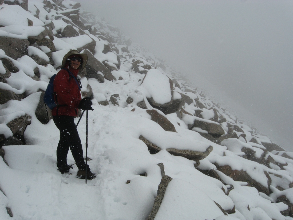
Hiking in the snow on Mt. Whitney
After 45min on the peak we decided to head back down. With more people coming up now a trail started to define itself. It was still snowing though. At the John Muir Trail intersection we met a guy who told us that a ranger had come through and recommended to people not to attempt the peak today. Probably a good idea. The climb back up to Trail Crest from the John Muir intersection was a bit slippery with the wet snow. We were glad it was not cold enough to freeze that stuff as that would have been a real "adventure" without at least Mircospikes. The top portion of the switchbacks was also slightly slippery with snow slush.
From Trail Camp down it was nice and warm and we made good time. Once back at the Portal we went straight for the shower at the Whitney Portal store. A nice service they offer, but bring some flip-flops since the shower floor did not look like something I'd want to step on with bare feet. As I came out of the shower the guy who runs the store stopped me and wanted to know if we summitted and what the conditions were like on top. I told him and he said everyone he'd talked to so far had turned around. I can believe that since we saw many people heading up whom we did not see either on top or on the way back. If we hadn't worn our heavy leather boots and been in light desert boots or even trail runners like a lot of people we saw, we likely would not have tackled the snow either. As it was we were quite comfortable the whole time.
After some dinner we crawled into our bags and went to sleep quickly. Even though we had no views from the top the day turned out to be a great adventure and we had plans for another 14er (Langley) later in the week that hopefully would allow us to enjoy some Sierra views. During the night a noise woke us up. Something had hit our tent, we quickly dismissed it as a pine cone or something similar. In the morning, however, we noticed some very suspicious foot prints next to the tent and the theory emerged that a bear stumbled over one of the guy lines of the tent?!
Day 4: August 5, 2014
We woke us all refreshed with some minor soreness reminding us of the previous day's workout. After some coffee we broke down camp and headed down the hill. We drove north to Bishop where we stopped at the ranger station to gather some information about our next destination: Boundary Peak, Nevada's high point. The rangers suggested the trail from Trail Canyon rather than from the Queens mine due to road conditions. Apparently the Trail Canyon road is typically in better shape. Since we new neither approach we just went with the recommendation.
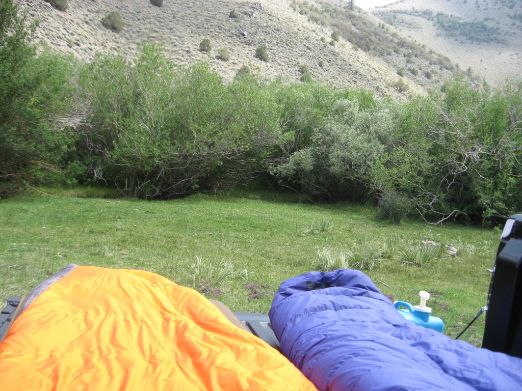
Camp at Trail Canyon trail head
After a big lunch (recovery meal after yesterday's hike) we stocked up on supplies and headed north to drive around the northern end of the White Mountains. Trail Canyon cuts into the mountains from the east. We found the turnoff onto the dirt road without problems and drove the 14 miles to the trail head.
The trail head turned out to be a very nice spot. There was a little stream in a meadow and lots of green, something I had not expected since the White Mountains are largely very dry. We set up camp and took a little nap. As were where getting our packs ready for the next day a car with hikers drove up. They were also headed to Boundery Peak the next day. After dinner we took a little walk up the canyon to scout the terrain and get a view of Trail Canyon Saddle, the spot where the Queen Mine and Trail Canyon routes merge.
With the skies relatively clear we decided to forego setting up the tent and to just sleep in the bed of the truck. As we were lying there in our bags reading a little before going to sleep we started to second guess our decision since some thunderstorms were moving along just to the south and east of us. Fortunately they did not make it to us.
Day 5: August 6, 2014
During the night we woke up and discovered that our sleeping bags were quite wet on top. We are too used to desert camping and did not think about due in a meadow with a little stream running through it. We had some big trash bags handy and used those to cover our bags for the rest of the night.
We woke up before sunrise, got ready and hit the trail at 5:40am with first light. There is a trail following the canyon staying just outside the dense bush which grows around the stream. Along the way we encountered a herd of cows and saw some deer. Towards the end of the canyon the trail turns left, but our target saddle was more to the right (north). We abondoned the trail and found the easiest route up to Trail Canyon Saddle. Once we started climbing we came across some cairns, but the terrain is easy enough and visibility good enough to just aim for the saddle.
- Distance hiked: 8.3 miles
- Elevation gain: 4200 ft (GPS)
- Time on trail: 8h 7m
- Time up: 4h 35m
- Time on peak: 36m
- Time down: 2h 55m
At the saddle met the trail from Queen Mine. A very obvious use trail leads up the ridge to the south of the saddle. We continued climbing on this trail. The surface is very loose and we were glad to have our hiking poles to prevent us from slipping back too much on the steep ascent. After some time we reached a ridge from where we got our first view of Boundary Peak.
From here the trail traverses the side of a mountain and Srisuda was very uncomfortable looking at the slope and the looseness of the trail. I convinced here to give it a try and we continued. The slope was really not steep enough that a fall would have resulted in anything serious. Once past this mountain we reached another saddle from where the remainder of the climb becomes a much more rocky affair.
At this point we spotted the hikers we had talked to the night before. They were coming up straight from the east side of the mountain. A very steep and tough looking slope. Once we reached the peak my plan had been to head down and over a saddle to Montgomery peak less than a mile away. The weather did not cooperate however, low clouds were moving in and we never even got a full view of Montgomery. At that point I deceided that Montgomery had to wait till another day.
We took a nice break and had some food before heading back. As we were leaving the peak we again saw the other hikers, they even yelled out to us asking if we were on the peak, but somehow they again made some unusual route choices, i.e., they did not take the easy use trail/cairned route and so we never actually met them.
The return to camp was quite quick and we were soon on the way in our truck. We decided to head out on a southerly route, different from where we had come in. The roads did not quite agree with what my maps showed but we made it back to pavement and then headed south to cross the White Mountains east of Big Pine. From there we headed back to Bishop and found a motel.
Day 6: August 7, 2014
On this day we obtained a permit for Cottonwood lakes which required a couple of trips to the ranger station (first to get on the list at 8am, then to get the actual permit at 11am). We also topped off our supplies. Once we had the permit we headed up to the mountains on Hwy 168 in the hopes of finding a nice picnic/rest spot, but unfortunately the lakes that can be reached by car are just for fishing and there is not much space to park and hang out.
Next we tried our luck out of Big Pine and ended up in a very nice area above Big Pine, so nice in fact that we picked a camp side on one of the campgrounds and stayed the night. We took a little walk along the creek and then went back to camp to pack our backpacks for a 2 night backpack trip to Cottonwood lakes.
Day 7: August 8, 2014
We again spent the night just in the bed of the truck, so breaking up camp was quick. We headed down the mountain and drove south to go up to the mountains again on Horseshow Meadow road. We reached the Cottonwood Lakes hiker parking lot mid-morning and found it to be full. Fortunately there is a large overflow parking area.
- Distance hiked: 6.5 miles
- Elevation gain: 1400 ft (GPS)
- Time on trail: 3h 38m
After storing our icebox and food items in one of the provided bear lockers we hit the trail and hiked straight towards Cottonwood Lakes. Our goal was lake #5 since that's close to Old Army Pass which we wanted to hike up on our Mt. Langley hike the next day. At least we wanted to check it out , the rangers we had talked to all recommended to take New Army Pass instead.
We reached our destination by early afternoon, picked a nice camp spot, set up the tent and rested with beautiful views. Looking at Old Army Pass it was quite clear to me that there could not be a route up that Srisuda would be comfortable with. So I decided to use New Army Pass instead. However, as we were having dinner I saw quite a number of people coming down Old Army. That made me wonder and I walked over to intercept some hikers to quiz them about the trail. I talked to some young kids who agreed that it looked impossible from the bottom but assured me that the trail was really not that bad. After discussing it with Srisuda we decided to give it a try and simply turn around if we both weren't totally comfortable.
Day 8: August 9, 2014
Today we wanted to hike Mt. Langley, one of CA's 14ers, and in the back of my mind I also had the idea of hiking up to Cirque peak nearby if time/strength allowed. We set out at 7:30am. At the time we already saw people moving up Old Army Pass .
- Distance hiked: 15 miles
- Elevation gain: 4300 ft (GPS)
- Time on trail: 11h 55m
- Time up to Langley: 4h 9m
- Time on Langley: 45m
- Cirque Peak detour: 1h to, 20min on, 40min from
- Time back to camp: 1h 51m
The Old Army Pass trail starts gentle, then gets a little steep with switchbacks, and finally heads along a rock shelf before reaching the pass. The whole trail was in great condition, packed "gravel" and of a comfortable width. There were a couple of spots towards the top where one wants to make sure of the footing and stay on trail since slipping would potentially take a hiker of the cliff....
From the pass we immediately saw the trail towards Mt. Langley. It climbs very gradually for a while before getting to the steeper and rocky climb for the last 2000 ft. Along the way we met a guy who had driven up the afternoon before to do the hike without artificial lighting just by moon light. We were a couple of nights before a "Super moon", so he picked the perfect time. He advised us that the route through the rocky portion was well marked by cairns. He was right, someone had done a lot of work putting up giant cairns, some of them over 7ft high. There was one 10 ft section where we had to use our hands to negotiate some rocks, very easy for everyone. Otherwise the route tries to avoid rocks as much as possible and one has to slog through very loose gravel/sand. It's a little tedious.
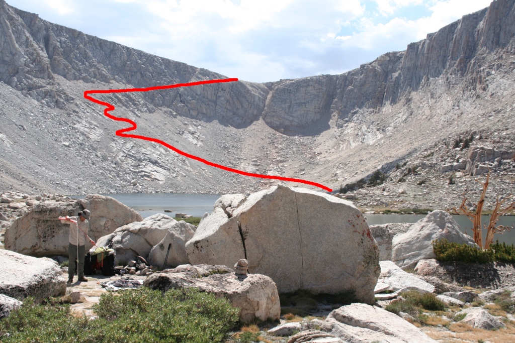
Approx. Army Pass Trail, Camp in front
Once on the top we were rewarded with great views of Mt. Whitney and the "rest" of the Sierra. Views that we were denied in the beginning of the week from Whitney. While enjoying the views we had some food and chatted with some fellow hikers. After about 45min we moved on.
We returned to Old Army Pass the way we had come and then headed up the ~300ft to New Army Pass. Here Srisuda decided to head down to the lakes while I wanted to make a quick detour to Cirque Peak.
The detour to Cirque Peak turned out to be rock hopping all the way. The size and shape of the rocks made it quite easy, but it did require concentration all the way since every foot placement was critical to avoid a twisted ankle or worse. About halfway to the peak I meet a group of people returning from the top. I reached the top about an hour after leaving the pass. While having some food I looked for an alternate route that would take me all the way down to the lakes. I had read that some people have gone that way, but no obvious choice presented itself. So I decided to play it safe and return the way I had come. The return went faster and I reached the pass in about 40min.
The New Army Pass trail is extremely gentle, i.e., with the chosen slope a lot of switchbacks/distance is needed to gain the elevation. To not have Srisuda wait too long I tried to get into a little jogging. Soon I reached High Lake and that's when I heard the first thunder from some dark clouds over Cirque Peak. A few minutes later I met up with Srisuda at Long Lake and we made our way through all those lakes to our camp. The thunder storm stayed to our south and we only got a few drops, not enough to worry about rain gear.
Sleep came easy again that night after we ate almost all the food we had left. We need to find more efficient ways to cram food into a bear canister.
Day 9: August 10, 2014
- Distance hiked: 6.5
- Elevation gain: 290 ft (GPS)
- Time on trail: 2h 40m
Time to go home. We cooked some coffee, prepared some oatmeal, broke up camp and hiked the 6.5 miles back to our truck. After retrieving our icebox and food items from the bear locker we headed down the hill. We made a couple of quick stops in Lone Pine, one for lunch, one to return the rented bear canister at the visitor center and then headed straight home. The mountains looked beautiful and the view was quite clear, reminding us that we should not wait too long to plan another visit